A number of snippets, bits of trivia and some longer tales about Lake Mitchell and its surroundings.
By Chip Gates, H.O.B.O. Historian
According to Wikipedia, a riffle is a short, relatively shallow and coarse-bedded length of stream over which the stream flows at slower velocity but a higher turbulence than it normally does in comparison to a pool. Riffles are usually caused by an increase in a stream bed's slope or an obstruction in the water. Our own Mitchell Dam was built at Duncan’s Riffle.
Did you know that Smith’s Ferry used to cross the river just below where Cargile Creek entered? Note: On U.S. Geological Survey maps, Cargile Creek back in 1891 was spelled Cargal, and then in 1903 it was spelled Gargyl. Whatever the spelling, the road leaving the ferry on the Coosa County side used to go due south and ran along the east side of a creek that is now the west branch of Big Y Slough. The road then turned eastward, running on the north side of the creek that is now the right branch of Big Y Slough. On the 1903 USGS map there was one house (cabin?) near where the back of the right branch is. The road continued eastward, crossing Pennymottley (sic) Creek and on to Traveler’s Rest, near present-day Kelly’s Crossroads. With regard to this same map, on the west side of the river you’ll see the Blue Creek Lumber Railroad, and still on the west side of the river overlooking Duncan’s Riffle was Carroll Bluffs.
Speaking of ferries, the Higgins Ferry did go into what is now called Ferry Branch on the Coosa County side. Driving your wagon, riding your horse or just plain walking off the ferry and heading due east, you would eventually cross over a relatively narrow Weogufka Creek and find yourself in beautiful downtown Dollar. Today there is one house where this community used to be. According to Ray Petty, water for this house used to come from a spring on the opposite side of Weogufka Creek! This most excellent water was piped under the creek and to the house. An old cast iron bath tub in the yard was utilized in which to keep freshly caught fish.
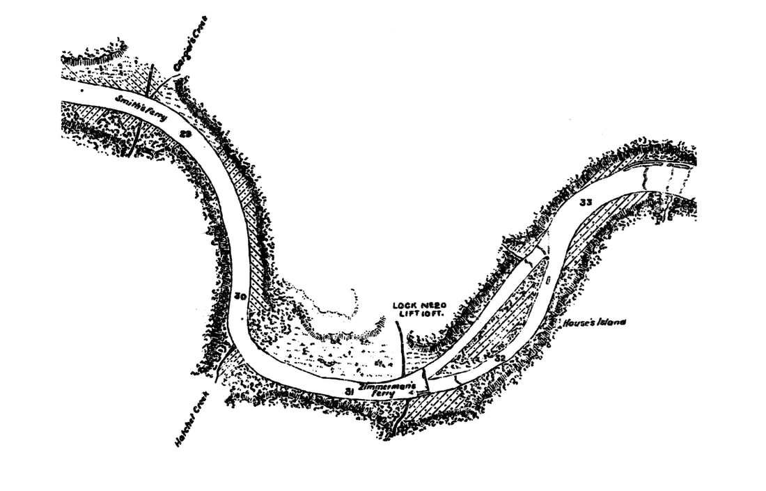
The last ferry operating on our lake was Mims Ferry. A 1948 U.S. Dept. of Commerce map referred to it as the Mims Free Ferry. This ferry shut down after the Alabama Hwy. 55 bridge, just below Lay Dam, was completed. For some aerial pictures of this ferry in use, go to the following site: http://alabamamaps.ua.edu/aerials/index.html. From the list of counties select Chilton. From that list scroll down to Lay Dam. In the 1958 photo you’ll see the ferry mid-river, the 1964 photo shows the ferry docked on the Chilton County side, and in the 1972 picture the ferry is just off the Coosa County shore. The 1978 photo shows the Hwy. 55 bridge under construction.
In the mid-1850s Weogufka was known for very large families. Evan Calfee had 16 children, Benjamin Callaway with 21, Robert Taylor with 25, and W. A. Wilson with 12. Some years later George Cram, a well-known cartographer of the day, published a map in 1884 showing a community near Weogufka named Callaway. This was probably made up largely of ol’ Ben’s children and grandchildren! Callaway town was southwest of Weogufka and north of Dollar. If the name Callaway seems familiar to you, it may be because of gardens or golf balls, or because that is what Cargile/Cargle Creek used to be called in the mid-19thcentury.
On the west side of Weogufka Creek where it flows into Hatchet Creek, there used to be a Creek Indian village called Pumpkin Town. A white man named Greenberry Clark, who lived among and adopted the ways of the Native Americans in that village, was called “Chief” by traders and other whites that visited there. Clark’s first name is also sometimes spelled Greenbury. According to The Alabama Historical Quarterly, Vol. 4, No. 01, Spring Issue of 1942, Clark later became a constable among the whites.
Did you know that on an 1891 map, just below Ware Island (very northern part of the Lake, has an airstrip on it) there was a place in the river called Butting Ram Shoals? This spot, now well concealed beneath the water, is located between the northwest side of Gilchrist Island and where Chilton County Road 834 dead ends at the lake. Not much is known about Butting Ram Shoals, unless you consider its mention in a story about arguably the most famous river boat journey ever on the Coosa River. The story is recounted in Harvey H. Jackson’s Rivers of History. It was in May 1864 that General Sherman’s army approached Rome, Georgia. Rome is where you’ll find the confluence of the Etowah and Oostanaula Rivers. From this point southward, the combined waters are called the Coosa River. Back to our story, the Confederate steamers Laura Moore and Alphretta, two very valuable boats that would be a considerable loss to the Southern cause, were docked in Rome. The commanding officer for the Confederates asked the captain of the Laura Moore, Cummins Lay, to try to keep the boats out of the hands of the soon-to-arrive Federal troops. Late on the night of the 17th Lay and his crew boarded the steamers, placed thick bales of cotton around critical areas of the ships, such as the pilothouse and boiler rooms, and then loosed their moorings. Drifting for a while in the dark to avoid unwanted Federal attention, the engines eventually had to be started. Sparks from the smokestacks, as well as thick smoke from the same, alerted Federal troops on a nearby ridge, who then began a furious barrage of gun and cannon fire against the ships. The cotton bales performed as intended and absorbed the shot, and neither ship suffered serious damage. Both vessels eventually made it to Gadsden, and later, riding high water on a rain-swollen river, travelled on to Wilsonville. There the Alphretta was tied up. Captain Lay, making use of the still high water level, navigated the Laura Moore over the highly treacherous shoals and rapids of the lower Coosa. Hell’s Gap, The Narrows and Butting Ram Shoals were some of these, and the last was The Devil’s Staircase, now under Lake Jordan. Captain Lay then took the Laura Moore on to Mobile, and in so doing, became the only person to ever take a steam boat the full length of the Coosa-Alabama river system. The Lay name is no coincidence: Cummins’ son William Patrick went on to start the Coosa-Alabama River Impoundment Association (CARIA) in 1890, as well as the not-so-insignificant founding of the Alabama Power Company. The Lock 12 Dam was renamed in his honor in 1929. In much more recent history, June 6, 2014 to be exact, the Coosa Riverkeeper organization’s new boat was christened the Laura Moore II, in honor of the earlier steamer.
Ed Clapp III (area 5) furnished the following historical information on the formation and extent of Baker County and its namesake. In 1820, not long after the state was formed (Dec. 14, 1819), the northeastern portion of Bibb County reached the Shelby County line and included that which is now the town of Jemison. Some 49 years later on Dec. 30, 1868, Baker County was formed from parts of Bibb (the eastern portion), Shelby, Autauga, and a small portion of Perry County. Ed was knowledgeable in this area because his mother’s family was from the Jemison area, and all their records, dating from the early 1800’s, had Bibb County on them. Furthermore, in looking up some old records, Ed found some amusement in the subsequent name change from Baker to Chilton County. From Wikipedia we learn Baker County’s namesake, Alfred Baker, founded Clanton in 1868, naming it in honor of Confederate Brigadier General James H. Clanton. The town of Clanton was incorporated on April 23, 1873, with Mr. Baker being elected its first mayor. This was not surprising, as The Central Alabama Genealogy website (www.alagenealogy.com) says Baker owned practically all the land that now constitutes Clanton. However, on Dec. 17, 1874, the county’s name was somewhat abruptly changed to Chilton, in honor of Judge William Parish Chilton, who had died in 1871. According to Ed, the folks around Clanton, the county seat and largest town, decided Mr. Baker was a little too closely associated with northern carpet baggers. A sufficient number of residents petitioned the state legislature to rename the county after the state’s former Chief Justice and the change was adopted. Justice Chilton never lived in the county that came to bear his name, but those that did back then were apparently more comfortable with his name than Baker’s. And from the “What if” department, think about this: If Baker had remained the county’s name, and that is where you obtain your car tags, the license plates would start with a 5 instead of 14. Coosa county tags though would still bear a double deuce at the beginning.
Did you know that prior to the 1958 completion of the Hwy. 22 bridge, in order to cross the Coosa River you would leave Hwy. 22, go south about a third of a mile and board a ferry? In the late 19th and through the mid-20th century this was known as Knights Ferry. Ed Clapp remembers when he was a 10 year old and his grandfather took he and his brothers to ride this ferry the last day it was in operation. Ed said they must have crossed the river 10 times that day. Afterwards his grandfather took the boys up to the Mims ferry and they rode it at least twice. What 10 year old boy wouldn’t have good memories of a day like that!
When the Hwy. 22 bridge was built, the deep cut through the rock on the Coosa County side exposed the minerals actinolite-tremolite, gneiss and hornblende. Caution: Dust from asbestiform varieties of actinolite and tremolite can cause serious and irreversible lung disease when inhaled. Rock hounds should be careful and avoid creating or inhaling the dust.
Staying in the neighborhood but much earlier, in 1900 the Coosa County community of Knights had a post office, though it apparently didn’t serve many constituents. This is based on the annual salary its postmaster, J.M. Wyatt, received, which was $50.97. Back across the river in Chilton County, the postmaster of Burwell, W.N. Pierce, that same year took in $67.78. Burwell, you say? Well, today if you turn off Hwy. 22 and head north towards The Ridge or Mitchell Dam, you would drive right through it. Assuming it was still there, of course. And remember Dollar, just up Weogufka Creek and around the bend from Fixico? Postmaster J.H. Warnick no doubt had to supplement his meager yearly earnings of $19.47. Perhaps Mr. Warnick worked in one of the nearby mines or lumber mills when not handling the mail. Finally, just for reference sake, in 1900 these postmasters fared somewhat better financially: James G. Downs at Cooper earned $121.67, Francis A. Gulledge down in Verbena got $383.15, while at the big post office in Clanton Joseph B. Downs pulled in a whopping $792.28.
Before the turn of the 20th century there was a community named Enid located on the north side of Cargile Creek, between what is now Pumphouse Slough and the river. From Wikipedia comes this – Enid is a female given name, its Middle Welsh origin meaning purity. Somewhat refreshing isn’t it, that some of Chilton County’s water is drawn from a slough in this very same area? As late as 1949, Enid appeared on the General Highway Map of Chilton County, although on this particular map it was shown due north of the back end of Pumphouse Slough. So who was she, this 19th century girl or woman named Enid, for which the community was named?
A newer version of the General Hwy. Map of Chilton County, printed in 1965, no longer shows Enid, but it has these additions: Between Yellowleaf Creek and Mims Ferry is Traywick’s Fish Camp, the boy scout’s Camp Arrowhead is shown just below the mouth of Bird Creek, and Dixie’s New Fish Camp appears in the somewhat circular slough that is south through a land gap towards the back end of Cargile Creek.
Travelling many moons back in time we come upon the Indian village Pakan-Tallahassee. This village has been described as being in two locations: on the west side of Hatchet Creek within four miles of the river, and on both sides of the Coosa River at its confluence with that same creek. Pakana, a variation of Pakan, is a Creek word for peach, a fruit the local Indians first obtained from the Spanish. Pakana Tallahassee means Old Peach Town. Now wouldn’t it be something if the Creek Indians also chose a peach queen each year? As for the Spanish, there is a map that traces DeSoto’s route south into Alabama in 1540. In 1918 the Alabama Anthropological Society postulated that DeSoto and company crossed the upper reaches of Hatchet Creek in Coosa County somewhere between the 21st and 29th of August. However, in 1928 a Mr. J.Y. Brame claimed that during this same 1540 late summer timeframe DeSoto was much closer to the river, crossing Hatchet roughly 5 miles upstream of its mouth. The settlement where Brame believes DeSoto spent the night on Hatchet Creek was at the time called Itaba. Could Itaba have later become Pakan-Tallahassee? Wherever he stayed, with the coming of the lake, any DeSoto Slept Here signs have long since disappeared.
John LaTourrette with Colton & Co. put out a map way back in 1837 that contained some interesting bits of information. One of these concerned House’s Island (now submerged, between Higgins Ferry and Walnut Creek), which back then was called Big Island. Another was a notation regarding the location of Poken Tallassee Council House, a Creek Indian gathering spot. On LaTourrette’s map it was shown about ½ mile due south of the mouth of Weogufka Creek, which looking at a modern day map would put it just above the mouth of Bee Branch. However, this historic place has also been shown just east of Pennamotley East (area 13A), near present-day Mimosa Point Road. Just plain Poken (without the Tallassee Council House notation) appears on a number of late 19th century maps, and most place it on the south side of Hatchet Creek, about halfway between Pennamotley and Weogufka Creeks. So I’ll leave you with this thought: Poken and Pakana, Pakan Tallahassee and Poken Tallassee. Very similar, aren’t they? Perhaps all are one in the same, but in different locations at different times.
In 1886 a map maker named W.S. Hoole showed a community on the south side of Hatchet Creek opposite the mouth of Weogufka Creek. This place was called Varnerton. In 1887 on another map it was spelled Varneton, but it wasn’t long before it disappeared from all maps completely.
In 1957 the US Geological Survey indicated Elmer’s Camp to be on the east side of Pennamotley.
If you want to go island hopping in time, know that on a 1929 map of Coosa County Ware Island (airstrip, north end of the lake) was known as Johnson Island. Just south of that what we now know as Gilchrist Island was called Pate’s Island. Somewhat surprising, House’s Island (formerly known as the Big Island) in the middle of the river opposite present-day Higgins Ferry boat launch, is still shown above water, some 6 years after the gates were closed on Mitchell Dam. Much more recently it was said one year Alabama Power lowered the water level quite a bit for shore line clean up and dock repairs and it was possible to stand in the middle of the lake, in front of the Higgins Ferry Park, and not have to tread water.
Doctors Harrison Rippatoe, Thomas Riser and Ed Gant practiced medicine at or near Sylacauga from 1837 to 1844. In the same time frame there was a gold mine back in the hills and just north of Blue Creek called Rippato’s [sic] Mine. With a distinctive name like that, there has to be a connection to the doctor. It has been said the gold from this mine was not so much in rock form but a very fine powder, like flour. Chan Aldridge (area 1a) provided that last nugget of information. South and slightly west of the Rippatoe Mine was Judge Terry’s Gold Mine, and just below this mine were the Goldwaite and Walker Gold Mine. These last two mines were closer to the main road of the time (the predecessor of Hwy. 31) than the river and were just east of the Chestnut Creek Post Office. John LaTourrette with Colton & Co. published this information way back in 1837.
If you are familiar with Popeye and watched his cartoons as a child, you may find it interesting to know his “roots” drew their sustenance from the Coosa River, albeit a little upstream from Lake Mitchell. This was taken from The Messenger, a Gadsden-based community newspaper.
Back in 1913, the lock and dam at Mayo’s Bar in Georgia was completed by the U.S. Corps of Engineers, making navigation over the Horse Leg Shoals of the Coosa River easier. The dam raised the water level about 10 feet. Charged with keeping the channel clear, the corps used the boat “Annie M,” later re-named “Leota.” The boat’s captain was named Sims, who was a resident of Ohatchee. His son Tom became a comic strip artist when he inherited the strip “Thimble Theatre” from creator Elzie Segar. The strip’s story line dealt with the Oyl family that owned a shipping business. Commodore Oyl had a son, Castor, and a daughter named Olive. One of the sailors that worked for the commodore was a wise-cracking and spinach-eating chap named Popeye. Tom Sims took that character, spun him off and gave him his own strip, thus creating Popeye the Sailor Man in 1929. Tom Sims was quoted as saying, “Fantastic as Popeye is, the whole story is based on facts. As a boy, I was raised on the Coosa River. When I began writing the script for Popeye, I put my characters back on the old Leota that I knew as a boy, transformed it into a ship and made the Coosa River a salty sea.” So who among you knew that Olive Oyl had a brother? While you’re pondering that, you should also know that Olive had a couple of uncles, obviously on her dad’s side. One was named Otto Oyl and the other, described on Wikipedia’s web site as an “intrepid explorer”, was named Lubry Kent Oyl.
Old Salem CemeteryThe next time you’re at G.R.A.C.E.S. Marina on Cargile Creek, go directly behind it (just to the west) and look for a small, fenced and somewhat overgrown plot. This is the Old Salem Cemetery. The Salem Church associated with this cemetery and the land on which it stood was sold to Alabama Power prior to the completion of Mitchell Dam. The church was torn down and the congregation went elsewhere for services. Of the 90+ graves within the boundaries of the cemetery, it was determined a few in the northeast corner would be in danger of being washed away when the lake was full. Rather than relocate all the graves, that corner was built up so as to resist erosion. The greatest threat to visitors now is red bugs, snakes and poison ivy.
|
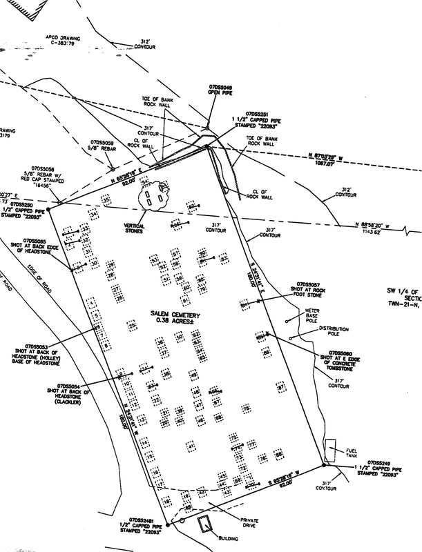
Old Salem Cemetery
|
In the early 1880’s, if you boarded the train at the depot in Clanton and headed down to visit your kin in Verbena, the stops along the way were Freeman, Swift, Anderson, Gullahorn, and Cooper (aka Cooper’s, aka Chestnut Creek), in that order. All this stopping and starting would have required a lot of work on the part of the brakemen riding on top of the cars. That is unless the train was equipped with George Westinghouse’s newfangled air braking system, patented in 1873. By the way, the Louisville & Nashville Railroad was then known as the South & North Alabama Railroad. This tidbit was gleaned from H.C. Hudgins & Company’s 1882 Rail Road & County Map of Alabama.

|
Lake Mitchell HOBO, P.O. Box 1324, Clanton, AL 35046
|